

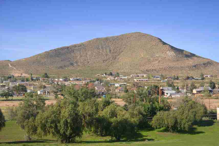
Sierra Blanca is a striking mountain peak located in Hudspeth County, Texas. Rising to an elevation of 6,892 feet (2,101 meters), it stands as the highest point in the Sierra Blanca range and one of the most notable landmarks in far West Texas. The mountain lies about six miles northwest of the town of Sierra Blanca, a community that shares its name. “Sierra Blanca” translates from Spanish as “white mountain,” a reference to the pale rock and light-colored vegetation that mark its slopes.
Geography and Elevation
The mountain dominates the surrounding desert landscape, rising roughly 2,400 feet (730 meters) above the plains in just two miles of horizontal distance. This dramatic elevation change gives Sierra Blanca a commanding presence visible for many miles, including from Interstate 10, which passes to the south. It is often regarded as one of the most recognizable natural features along this stretch of highway, serving as a navigational landmark for travelers crossing the Trans-Pecos region.
Geological Formation
Geologically, Sierra Blanca is part of a cluster of five rhyolite laccoliths—dome-shaped intrusions of volcanic rock that forced their way into overlying sedimentary layers during the Tertiary period. These intrusions pushed the older limestone strata upward, forming the rugged peaks visible today. Over time, erosion removed much of the surrounding softer rock, revealing the harder rhyolite cores. Nearby peaks such as Round Top, Little Blanca Mountain, and Twin Mountains share this same geologic origin, together forming a distinctive volcanic landscape unique to Hudspeth County.
Natural Environment and Significance
While the region is arid, Sierra Blanca’s slopes support hardy desert vegetation, including grasses, cacti, and shrubs adapted to the high elevation and limited rainfall. The lighter coloration of its rhyolite and limestone surfaces gives the mountain its “white” appearance, which likely inspired its Spanish name. The peak also provides panoramic views of the surrounding desert basin, including the Sierra Diablo and Eagle Mountains in the distance.
Modern Context
Sierra Blanca Peak remains a point of geographic and scientific interest. Geologists continue to study its laccolithic structure to better understand volcanic processes that shaped much of West Texas during the Tertiary age. The area’s remote setting and visual prominence also make it a reference point for travelers, pilots, and topographic surveys. Though it is located on private land and not developed for public recreation, it continues to draw the attention of hikers, naturalists, and photographers interested in Texas’s volcanic past.
Photos:
Map:
Sorry, no records were found. Please adjust your search criteria and try again.
Sorry, unable to load the Maps API.
Hudspeth County
Texas
79851
United States
Yes
- Hiking
- Camping
- Wildlife Observation
- Picnic Areas
- Restrooms
- Parking Facilities
Ricraider, Sierra Blanca TX, CC BY 3.0