
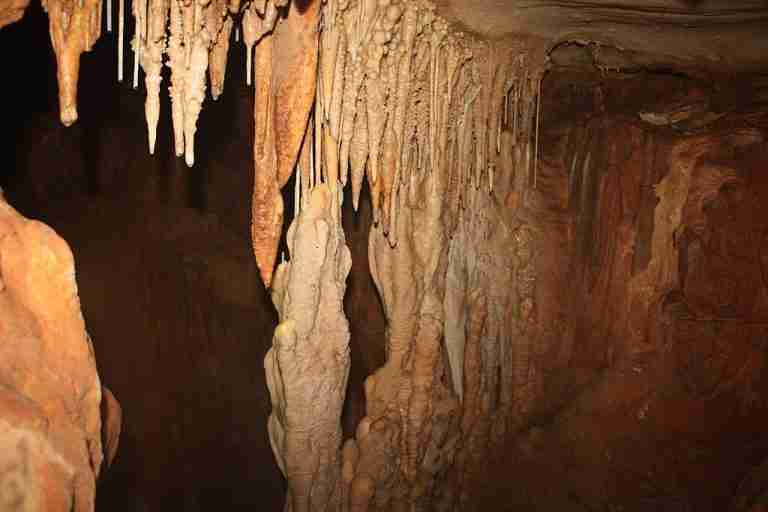
Cambria Cavern is a small limestone solutional cave located beneath Cambria Drive in the Brushy Creek neighborhood of Round Rock, Williamson County, Texas. It lies within a modern residential subdivision where the cave had remained unknown until 2018. The feature formed in Edwards Group limestone, part of the broader karst landscape of Central Texas, where slightly acidic rainwater slowly dissolves the rock and creates caves, fractures, and sinkholes. Estimates based on the regional geology place the age of the cave formation at tens of millions of years, consistent with the age of the Edwards Plateau cave systems.
The cave meets the standard definition of a cave used in Texas, which requires a naturally occurring, humanly enterable cavity of sufficient length. Before 2018, Cambria Cavern had no natural surface entrance and sat only a few feet beneath pavement and yards, entirely hidden from view. It became a closed and sealed feature after stabilization work later that year.
Discovery Beneath a Neighborhood Street
Cambria Cavern was discovered on February 8, 2018, when a portion of its roof collapsed beneath Cambria Drive. Residents in the 8400 block of Cambria Drive reported a water outage that morning, and utility crews from the Brushy Creek Municipal Utility District were dispatched to investigate. When they opened the pavement, they found that a water line had dropped into a large void in the limestone. Further inspection revealed an extensive underground cavity that geologists soon named Cambria Cavern.
News reports and engineering summaries note that the collapse created a sinkhole-like opening in the roadway, with additional sections of pavement failing as crews worked around the site. Early mapping showed that the newly exposed cave extended under the street and beneath nearby houses. Some reports describe it as passing under three homes in the subdivision, while at least one engineering firm notes that the mapped passage extended under two homes. In either case, it was clear that the feature lay directly beneath existing development and required careful assessment.
Size, Chambers, and Interior Features
Survey work carried out soon after the discovery and refined through 3D mapping in May 2018 documented the basic dimensions of Cambria Cavern. The cave is commonly described as approximately 200 feet long, with some sources giving lengths in the range of about 170 to 230 feet. It is a relatively shallow cave system, with the roof in places only about five feet below the street surface. The interior width in some sections approaches 40 feet, creating a broad main chamber.
The cave consists of a series of connected chambers. Initial mapping identified at least three chambers, which were thought to extend eastward under the residential lots. Later work increased that number. County releases and local coverage describe four chambers with heights ranging from about 22 feet in the tallest section to about 3 feet in the lowest. During mitigation activities on August 1, 2018, workers uncovered an additional void that was designated a fifth chamber. This additional feature required adjustments to the stabilization plan.
Inside the cave, geologists reported extensive speleothems, including stalactites, flowstone, and a large flowstone column in the main chamber. Some of these formations were broken during the collapse and during the creation of a safe entry opening for engineers. Portions of the ceiling and walls were also disturbed as crews enlarged the opening and installed supports needed for mapping and later concrete placement.
Karst Setting and Environmental Context
Cambria Cavern sits within the Edwards Plateau region, an area known for its karst topography and numerous caves. The Edwards Group limestone underlying this part of Williamson County contains thousands of caves and solutional voids. Water moving through fractures and bedding planes enlarges openings over millions of years, and some caves become significant conduits for groundwater flow that feeds the Edwards Aquifer and related systems.
Local reports emphasize that the cave under Cambria Drive is one of many in the county and that similar voids exist beneath other developed areas. Nearby caves in Round Rock are known to host specialized cave invertebrates, including endangered species such as the bone cave harvestman and the coffin cave mold beetle. While Cambria Cavern itself was primarily managed as a structural and public safety concern, regulators and consultants still treated it as a sensitive karst feature linked to the regional aquifer system.
Because caves can act as rapid pathways for contaminants to reach groundwater, the Texas Commission on Environmental Quality reviewed the county’s mitigation proposals. Any stabilization method had to account for both the structural safety of the road and homes and the need to protect the aquifer from pollutants associated with road reconstruction and utility work.
Safety Concerns for Homes and Infrastructure
From the time of discovery, Cambria Cavern presented two overlapping risks. The first was structural, since a void only a few feet below the surface had already caused a street collapse and threatened buried utilities. Engineers examining the cave measured at least about five feet of rock between the road surface and the cave ceiling in parts of the feature, but the collapse indicated that this thickness alone did not guarantee long-term stability.
The second concern involved the presence of homes directly above portions of the cave. Mapping showed that multiple houses sat over chambers and passages within the system. County officials noted in public briefings that stability under these homes had to be evaluated carefully. Geologists reported that they did not see signs of active disturbance in some of the more distant portions of the cave ceiling, yet the potential for additional collapses remained a serious consideration. As a result, access to the area was restricted, and both scientists and the public were kept away except for authorized work.
Mitigation, Concrete Filling, and Road Reconstruction
Williamson County engineers, working with consultants including Cambrian Environmental and other geotechnical firms, developed a sensitive feature mitigation plan for Cambria Cavern. The plan focused on stabilizing the roadway and utilities above the cave while also sealing exposed fractures and voids that could become pathways for contamination. The Texas Commission on Environmental Quality reviewed and approved this approach.
The approved plan called for partially filling sections of the cave and associated fractures with flowable concrete. This included boring access holes from the surface into specific chambers and fractures, then placing concrete to support the road and utility trenches. In some areas, crews used geogrid and wire reinforcement in combination with the concrete to provide additional strength and distribute loads. The goal was not to fill every open space, but to secure the portions under and near the right of way and to close off features that intersected the reconstruction of water, sewer, and other utility lines.
Work on mitigation and reconstruction began in late July 2018, when contractors started replacing utilities and preparing to rebuild Cambria Drive. As crews advanced, they encountered the fifth chamber and additional fractures, which required amendments to the original plan and fresh approvals from regulators. Additional filling and sealing were completed over the following weeks. County statements and news coverage report that the main phase of concrete placement concluded on August 31, 2018, allowing full road and utility reconstruction to continue under more normal construction conditions.
By early autumn 2018, remediation of newly identified fractures near the cave was also underway. Regulators approved plans to fill those smaller voids with concrete to prevent future subsidence and to protect the underlying aquifer system from surface contamination. Once the mitigation was complete, Cambria Drive was reopened to traffic, and the area returned to routine residential use.
Present Status of Cambria Cavern
Today, Cambria Cavern is a closed and sealed cave feature beneath a quiet Round Rock neighborhood street. Access is not available for public tours or recreational caving. The cave exists in the geologic record as a documented karst feature that required significant engineering intervention, and its interior is preserved digitally through 3D mapping carried out before extensive filling took place.
For Williamson County and Round Rock, Cambria Cavern highlights how common caves and sinkholes are in the region, even in fully built suburban areas. It also illustrates the way local officials, engineers, and environmental regulators balance infrastructure safety with protection of sensitive karst environments and groundwater resources.
Photos:

Rock formation
Map:
Sorry, no records were found. Please adjust your search criteria and try again.
Sorry, unable to load the Maps API.
Brushy Creek
Texas
78717
United States
Not applicable, as the cavern is sealed and inaccessible.
Not applicable.
Not applicable.