
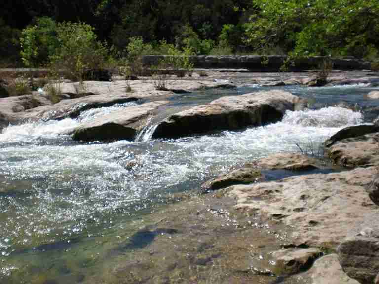
Barton Creek Greenbelt is a long stretch of public land in Austin, Texas, managed by the City of Austin Parks and Recreation Department. It follows Barton Creek for about 7.25 miles from Zilker Park west to the Lost Creek neighborhood and is part of one of the city’s most popular open-space corridors. Some sources list the protected area at roughly 800 to a little over 800 acres, while others describe close to 809 acres and additional watershed parkland that has been added over time.
The Greenbelt sits close to downtown but feels removed from city streets. Sheer limestone bluffs, creekside flats, and thick vegetation line much of the route. The land also helps protect water quality in the Edwards Aquifer recharge zone and supports habitat for several native and endangered species in the Barton Creek watershed.
Trails, Terrain, and Access
The main trail through Barton Creek Greenbelt runs along the creek bed and connects a series of access points and neighborhood trailheads. Of the 7.25 miles that formed the original linear park, the uppermost segment is known as Barton Creek Wilderness Park, while downstream segments connect to Zilker Park near Barton Springs Pool. Some guides describe the current multi-segment system as closer to 7.9 or even 12 miles when side trails and extended connections are included, but the core Greenbelt route is typically described in the 7 to 8 mile range.
The terrain varies from rocky singletrack to wider creekside paths. Hikers encounter stretches of flat limestone bedrock, loose rock, roots, and short, steep climbs leading to overlooks or neighborhood access points. The area’s limestone cliffs, dense vegetation, and intermittent pools give it a canyon-like feel in places, even though it lies within the city limits.
Access points include trailheads near Zilker Park as well as popular entries along Loop 360 and residential streets such as Gus Fruh, Spyglass, and Scottish Woods. These trailheads provide different starting points for reaching swimming holes, climbing walls, and quieter stretches of trail.
Recreation and Popular Spots
Barton Creek Greenbelt is widely regarded as one of Austin’s top destinations for outdoor recreation. Visitors use the corridor for hiking, running, mountain biking, rock climbing, bouldering, and, when conditions allow, swimming in the creek. The subtropical climate in Central Texas means the Greenbelt can be used throughout the year, though high heat, flash flooding, and dry spells are common seasonal considerations.
Several spots along the creek have become well known. Twin Falls and Sculpture Falls are two of the most frequently visited swimming and lounging areas when Barton Creek is flowing. Reaching them typically involves hiking in from the Mopac or Loop 360 access points along the main Greenbelt trail. During wet periods, these falls form pools and cascades that draw large crowds; during drought, they may be reduced to shallow water or dry rock.
Other named locations include Gus Fruh, which features a sometimes deep swimming hole and nearby cliff bands, and the Hill of Life near the Lost Creek end, where a steep hill tests hikers and bikers on the way in or out. Overall, the mix of shaded sections, open rock, and water features has made the trail one of the most heavily used outdoor spaces in Austin.
Rock Climbing and Limestone Cliffs
One of the defining features of Barton Creek Greenbelt is its limestone cliff system. These rock faces form along the sides of the creek and provide numerous established climbing routes. Areas such as Seismic Wall, sometimes also called Maggy’s Wall, are specifically known as climbing destinations and are documented in local climbing guides and community resources. Other walls, including those near Gus Fruh and additional sites along the corridor, contribute to a variety of sport and top-rope routes.
The combination of accessible trailheads and short approaches to the cliffs has made the Greenbelt one of the main urban climbing areas in Central Texas. Climbers share the space with hikers and swimmers, and changing creek levels can alter the character of the approach to certain walls throughout the year.
Ecology, Conservation, and Endangered Species
Barton Creek Greenbelt sits within the Barton Creek watershed and plays a role in protecting water that flows into the Edwards Aquifer recharge zone. The corridor’s mix of riparian habitat, oak and juniper woodlands, and limestone outcrops supports a variety of plants and animals typical of the Hill Country region.
The creek and surrounding protected lands provide habitat for several federally listed or sensitive species. The Barton Creek area and associated preserves support endangered species such as the Golden-cheeked Warbler, the Austin Blind Salamander, the Barton Springs Salamander, and the rare plant known as Bracted Twistflower. Some of these species are associated with specific spring outlets, caves, or woodland habitats, and ongoing conservation efforts focus on preserving these environments amid development pressure in western Travis County.
Because the Greenbelt is both an ecological corridor and a recreation site, local organizations and city partners invest in trail maintenance, invasive species management, and education campaigns to encourage responsible use. These efforts aim to balance heavy visitation with the need to protect water quality and sensitive habitat over the long term.
Character and Reputation
Within Austin, Barton Creek Greenbelt is frequently described as one of the city’s favorite outdoor spaces. Tourism and parks organizations refer to it as a premier spot for outdoor enthusiasts and a standout example of an urban nature corridor. Its proximity to downtown, range of activities, and scenic limestone and water features have helped cement its reputation as a signature Austin experience.
On busy weekends, sections of the trail near popular swimming holes can be crowded, while other stretches remain relatively quiet, especially during cooler months or dry periods when the creek is not flowing. Despite seasonal changes, the Greenbelt continues to function as a major recreational outlet and an important conservation area within the city’s growing urban landscape.
Photos:

Map:
Sorry, no records were found. Please adjust your search criteria and try again.
Sorry, unable to load the Maps API.
Austin
Texas
78746
United States
Yes, pets are welcome but must be kept on a leash no longer than six feet. Owners are required to clean up after their pets to maintain the park's cleanliness and protect water quality.
- Hiking & Trail Running: Over 12 miles of trails suitable for various skill levels.
- Mountain Biking: Challenging terrains that attract bikers.
- Rock Climbing: Limestone cliffs offer climbing opportunities; popular spots include Seismic Wall.
- Swimming: Seasonal swimming holes like Twin Falls and Sculpture Falls are popular during periods of sufficient rainfall.
- Wildlife Observation: The greenbelt's diverse ecosystem supports birdwatching and nature study.
- Trailheads: Multiple access points with varying facilities.
- Restrooms: Composting restrooms available at select trailheads, such as Zilker Park and the 360 Access.
- Parking: Available at various trailheads; fees may apply during peak times.