

Mule Ear Peaks are two distinctive rhyolite spires located in Big Bend National Park, Texas. Rising from the arid expanse of the Chihuahuan Desert, these twin peaks resemble the upright ears of a mule, giving them their name. The south peak stands at about 3,897 feet (1,188 meters) and the north peak at approximately 3,882 feet (1,183 meters). Together, they create one of the most recognizable silhouettes in the park, visible for miles across the desert floor.
Geological Formation
The peaks are remnants of volcanic activity dating back roughly 29 million years, during the Oligocene epoch. They are composed primarily of rhyolite, a fine-grained volcanic rock that formed as molten material cooled and solidified near the surface. Mule Ear Peaks are part of the Burro Mesa Rhyolite Member of the Burro Mesa Formation, a geologic unit that records extensive volcanic processes in the Big Bend region. These formations likely originated from dike intrusions, where magma forced its way through older rock layers and hardened into the dramatic structures seen today.
Location and Landscape
Situated in the southwestern portion of Big Bend National Park, Mule Ear Peaks rise about 1,000 feet above the surrounding desert. Although sometimes associated with the Chisos Mountains, they are technically separate, standing as isolated volcanic remnants in the park’s desert basin. Their reddish-brown color and rugged contours contrast sharply with the flat desert terrain, making them a striking visual landmark for travelers along Ross Maxwell Scenic Drive.
Visiting and Hiking
Visitors can view the peaks from a designated viewpoint located along the Ross Maxwell Scenic Drive. This roadside overlook provides a panoramic view of the peaks and surrounding desert, making it a popular stop for photography and sightseeing. For a closer experience, the Mule Ears Spring Trail begins at this overlook and stretches about 3.8 miles (6 kilometers) round trip. The trail leads through desert terrain filled with ocotillo, prickly pear, and lechuguilla before reaching a natural spring at the base of nearby hills. The spring supports a small oasis of vegetation, providing a stark contrast to the surrounding arid landscape.
Historical Note
During the 1930s, Mule Ear Peaks served as a navigational landmark for Army Air Corps pilots who trained in the Big Bend region. Some flight exercises reportedly involved passing between the spires, a daring maneuver that highlighted the peaks’ prominence in the desert landscape. The area’s open skies and distinctive landmarks made it a useful site for early aviation training long before the establishment of the national park.
Natural Significance
Beyond their geological interest, Mule Ear Peaks stand as a reminder of Big Bend’s complex volcanic history and the enduring power of erosion in shaping the desert landscape. The area surrounding the peaks supports a diverse range of desert flora and fauna, offering visitors an opportunity to experience both the geological and ecological richness of this part of Texas.
Photos:
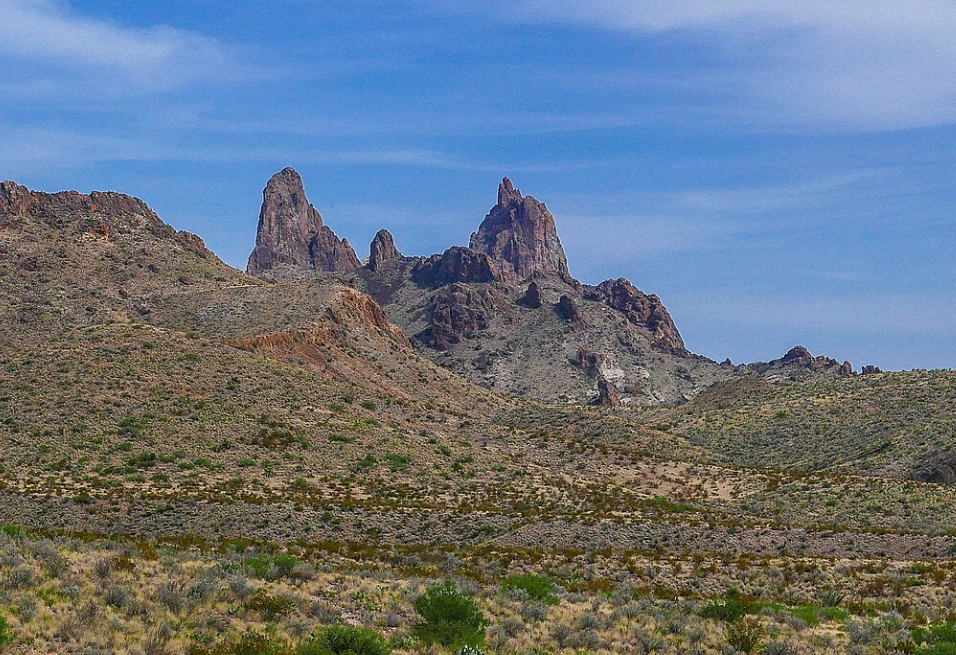
Mule Ear Peaks
Map:
Sorry, no records were found. Please adjust your search criteria and try again.
Sorry, unable to load the Maps API.
Texas
Texas
79834
United States
Pets are not permitted on trails, off roads, or on the river within Big Bend National Park.
- Hiking
- Photography
- Wildlife viewing, and geological exploration.
At the Mule Ears Overlook, amenities include parking for autos and RVs, wheelchair-accessible facilities, and interpretive signage.
Aryeh Alex, Mule Ear Peaks, Texas, CC BY 2.0